Visitors

Thursday, April 27, 2017

Ranking The 10 Most Dangerous Volcanoes, From Vesuviusto Santa Maria

ERIK KLEMETTI
SCIENCE
04.14.17.04.14.17


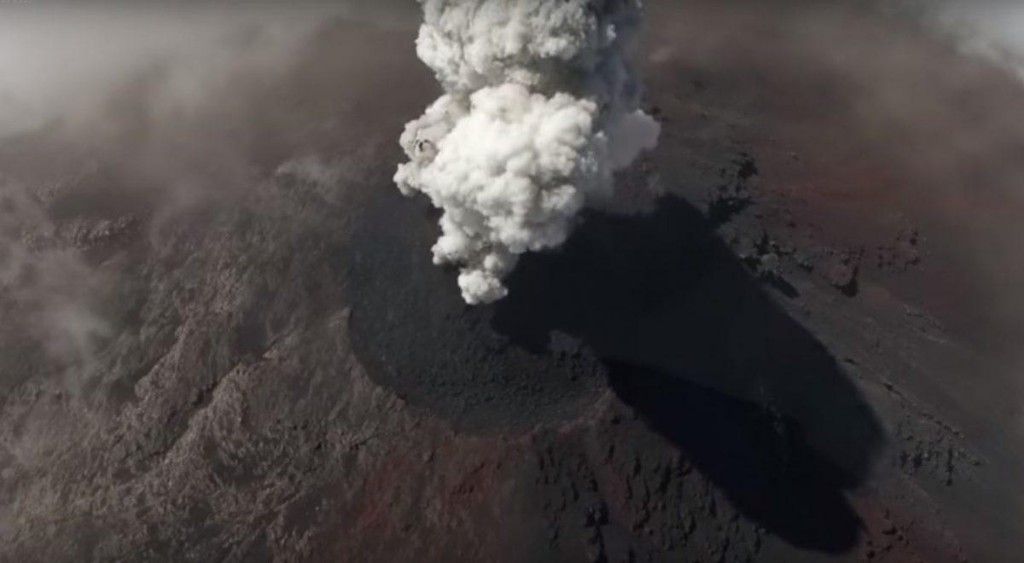
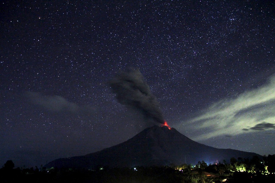
The Santiaguito volcano erupting.MARTIN RIETZE/GETTY IMAGES


TIME TO COUNT down some dangerous volcanoes. I’ve gone through what might make a volcano dangerous and how I tried to rank dangerous volcanoes, developing a points system based on population, magma type, volcano type, and past large explosive eruptions. Looking at some recent articles about “dangerous volcanoes,” my ranking comes to some pretty different conclusions. What my ranking boils down to is what volcano has the highest potential for mass casualties based population, style of eruption and potential for large explosive events.


I’ll start with some honorable mentions that fell outside the top 10 (in order of increasing danger): Pululagua (Ecuador), Guntur, Gede-Pangrango and Semeru (Indonesia), Popocatépetl (Mexico), Colli Alban (Italy), Dieng Volcanic Complex and Tengger Caldera (Indonesia), Nyiragongo (DR Congo), and Merapi (Indonesia).


Here are the top 10 (with people living within 30 kilometers and 100 kilometers listed.)


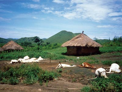
10. Santa Maria, Guatemala (1.25 million/6.2 million): This volcano might be best known for its most active vent, Santiaguito. It has the tendency to erupt explosively with VEI 6 eruption as recently as 1902.

9. Taal, Philippines (2.38 million/24.8 million): Taal is a lake-filled caldera that produced four VEI 4 eruptions in the last 200 years and a VEI 6 eruption only ~5,500 years ago (VEI stands for Volcanic Explosivity Index, and it tops out at 7). Combine that explosivity with abundant water to add to potential explosive eruptions and the large population that could be impacted by ash, and you have a very closely-watched volcano. Taal is monitored by PHIVOLCS, the Philippine volcano monitoring agency.

8. Coatepeque Caldera, El Salvador (1.2 million/6.5 million):Coatepeque is the first “dark horse” in the top 10. It gains points for erupting rhyolite and dacite, both magmas prone to large, explosive eruptions. It is also centrally-located in El Salvador, so a large eruption would likely impact the capital of San Salvador along with the city of Santa Ana. Like Taal, it is a lake-filled caldera, adding to its potential danger by potentially increasing explosivity or mudflows (lahars).

7. Corbetti Caldera, Ethiopia (1.2 million/9.8 million): Now, this is a real under-the-radar volcano. The Corbetti calderalies within an even older caldera and has produced pyroclastic cones (explosive eruptions of lots of volcanic debris) and obsidian flows, meaning it has the right style of eruption and right composition to potentially experience a big explosive eruption. Not much is known about the Corbetti Caldera, so it is hard to constrain its recent activity. However, it is close enough to Addis Ababa that a large ash-rich eruption might cause quite a humanitarian crisis.

6. Tatun Group, Taiwan (6.7 million/9.8 million): Much like the Corbetti Caldera, Tatun is not a well-known volcano in a country most people don’t associate with volcanism. However, as I wrote about recently, the Tatun Group has all the signs of a volcano that is still potentially active. It is also nestled close to Taipei, so you could imagine an eruption that produced another andesite dome could wreak havoc on the city, mainly from ash fall or mudflows.

5. Vesuvius, Italy (3.9 million/6.0 million): Did you really think Vesuvius wouldn’t be in the top five? The volcano is one of the most dangerous on Earth thanks to its numerous explosive eruptions—and the city of Naples, which is slowly crawling up its flanks. The fact that it doesn’t fall at the top of this list (heck, it’s not even the most dangerous in Italy) betrays how hazardous the other volcanoes might be. Vesuvius has been quiet since 1944, so we’re full into the “complacency” phase where most people don’t remember the last eruption—never a good place to be when 6 million people could be impacted by an explosive eruption.

4. Ilopango, El Salvador (2.9 million/6.7 million): This is another caldera in El Salvador. But unlike Coatepeque, it has erupted in the last 200 years (1880 to be exact). Around 450 CE, Ilopango had a VEI 6 eruption that covered much of El Salvador with ash and brought down Mayan cities across the region. Today, San Salvador sits directly next to the this lake-filled caldera, so the significant danger from this caldera remains after 1,500 years.

3. Aira Caldera, Japan (0.9 million/2.6 million): The population around the Aira caldera might be lower than most of the top 10 volcanoes, but its frequent eruptions (from Sakurajima) and history of large eruptions means it poses a large danger to those 2.6 million people within 100 kilometers. Over the past 10,000 years of the Holocene, the Aira caldera has had a half dozen VEI 4, 5, and 6 eruptions—so don’t be fooled by the constant din of smaller explosions from Sakurajima over the last decade.

2. Michoacan-Guanajuato, Mexico (5.8 million/5.8 million):Here’s the thing about the Michoacan-Guanajuato (M-G) volcanic field: All three population radius values are the same: 5.8 million. Yes, almost 6 million people live within 5 kilometers of this volcanic field that has produced pyroclastic cones generated by explosive eruptions. It has produced numerous VEI 3 and 4 eruptions over the Holocene from 1,400 vents. This means it hasn’t had big eruptions like some of the top 10. But the frequency, potential explosivity, and population in the widespread volcanic area makes it a high risk.

1. Campi Flegrei, Italy (3.0 million/6.0 million): If you’re the sort of person who wants to worry about Yellowstone, maybe you should turn your attention to the Campi Flegreiinstead. Not only is it a restless caldera with a more recent history of very large explosive eruptions, it is also smack in the middle of an area with over 6 million people … and it’s partially under the Bay of Naples. All these factors mean that if the Campi Flegrei has a new bout of explosive eruptions, the hazards could exceed those of any eruption in modern history. That being said, the last eruption (Monte Nuovo in 1538) was actually a fairly-benign cinder cone.


Now, this ranking is highly subjective. There can be a multitude of ways to measure danger, so I’m sure people will disagree with this list. Volcanoes like Etna, Cotopaxi, Ruiz, Fuego, and more didn’t make the top 20—mostly because I chose to put emphasis on the style and composition of magmatism.

The big important point here: This list highlights the most potentially “dangerous” volcanoes based on their past behavior (mainly) and the potentially for mass casualties. There will always be volcanoes that might only have a few thousand people living near it that could erupt and kills hundreds of people.

I think of eruptions like El Chichón in 1982 as a great example. The volcano wasn’t even really recognized as a threat until it erupted and killed around 1,900 people. It is unlikely that we can eliminate all volcanic threat, and as the global population grows, the danger posed by volcanoes we can identify as hazardous—and those we don’t recognize as hazardous—will only increase. Funding volcanic research and monitoring along with emergency management organizations is the only way we can hope to protect ourselves from major volcanic disasters.

Wednesday, April 26, 2017

This Small Lake in Africa Once Killed 1,700 People Overnight, and We Still Don't Know Why


BEC CREW
Science Alert
15 APR 2017


On 21 August 1986, one of the strangest and most mysterious natural disasters in history took place at Lake Nyos - a lake formed atop a volcanic crater in northwest Cameroon.

Without warning, the lake released hundreds of thousands of tonnes of toxic carbon dioxide - estimates range from 300,000 to up to 1.6 million - and this silent death cloud spread out over the countryside at nearly 100 km/h (62 mph), suffocating an estimated 1,746 people and more than 3,500 livestock within minutes.

The effect was as devastating as it was swift, and with the severity of a Biblical plague, it felled locals and wildlife alike by starving the air of oxygen within a 25-km (16-mile) radius of the lake.

Many people from the villages of Cha, Nyos, and Subum were silently asphyxiated in their sleep. Some were found with blood around their noses and mouths.

When the few remaining survivors woke up, they found no disturbances, no violence - just corpses. Even the flies had dropped dead.

Reporters in the area described it as like looking at the aftermath of a neutron bomb.

Joseph Nkwain, who woke up 3 hours after the cloud hit, recounted the experience to Plymouth University researcher, Arnold H. Taylor:

"I could not speak. I became unconscious. I could not open my mouth because then I smelled something terrible... I heard my daughter snoring in a terrible way, very abnormal...

When crossing to my daughter's bed ... I collapsed and fell. ... My arms had some wounds, I didn't really know how I got those wounds. I wanted to speak, my breath would not come out... My daughter was already dead."

It's one of the most gut-wrenching natural events in recorded history, and scientists still have no idea what triggered it.

"It was one of the most baffling disasters scientists have ever investigated. Lakes just don't rise up and wipe out thousands of people," George Kling, an ecologist at the University of Michigan, told The Guardian back in 2005.

Dead cattle after the event. Credit: US Geological Survey
So what do we know?


At the time, researchers determined that Lake Nyos had released a massive amount of CO2 at around 9pm, and because CO2 is heavier than the surrounding air, it quickly sunk into the valleys below, blanketing everything in a sheet of toxic gas 50 metres thick.

Usually, those hundreds of thousands of tonnes of CO2 are kept contained in the lake, but this time, something blew the lid off.

As David Bressan explains for Scientific American, volcanic gases emanating from the ground below the lake dissolve and become concentrated in its deepest waters, and the tropical temperatures form a sort of 'cap' of warm water above this cooler water.

It's not clear what 'broke the seal' and allowed the deep, contaminated water to rise, but it could have been an earthquake, a landslide, or a volcanic eruption, or even something as simple as heavy runs muddling the water levels.

The trigger was silent, but the effects were catastrophic.

"The lake literally exploded in what's known as a limnic eruption, sending a fountain of water over 300 feet (91 metres) into the air and creating a small tsunami," Atlas Obscura reports.

In the absence of a scientific explanation, conspiracy theories reared their inevitable heads, with some locals convincing themselves that the eruption had been triggered by an undisclosed bomb test, carried out by the Israeli and Cameroon governments.

But the timeline just doesn't fit.

Weirdly enough, a similar event happened nearby just two years earlier at Lake Monoun, where a CO2 eruption killed 37 people. No one knows what triggered that eruption either.

To prevent these lakes from exploding once more, in 2001, engineers installed pipes in both to suck CO2 from the lake bed, and release it very gradually into the air.

Another set of pipes were installed in 2011 after researchers warned of a gas burst "that could be bigger than either of those disasters".

With that problem solved, another one arose - the natural wall surrounding Lake Nyos started to weaken, and the concern was that if something were to shift the earth around it and dislodge it, there's no telling what would happen if the contents spilled out.

A dam has since been built around the wall to protect it, and while researchers think it will hold into the near future, processes such as weathering or lake overflow "can cause instant failure".

Let's just hope scientists figure out a way to predict the lake's activities well in advance, so nothing like the events of 30 years ago happen again.

Tuesday, April 25, 2017

See Close-Up View Of Dangerous Volcano Eruptions Via Drone


Volcan de Fuego erupting


Eric Mack
12 Apr 2017
Forbes Magazine


Guatemala is known for its volcanoes — some spew lava slow enough that tourists can hike right up to the flows, while others are too violent for even the most dedicated volcanologists to go near.


One such rowdy caldera can be found at Volcán de Fuego, which erupts frequently, preventing access to the summit for scientists anxious to measure its emissions. Researchers and engineers from the Universities of Cambridge and Bristol flew fixed-wing unmanned aerial vehicles (UAVs) to observe and measure eruptions in their place.


The drones carried a suite of lightweight modern sensors to measure temperature, humidity and volcanic cloud thermal data while also taking some stunning photos and video footage of eruptions in real time from a rare (brave) bird’s eye view.

“These sensors not only help to understand emissions from volcanoes, they could also be used in the future to help alert local communities of impending eruptions – particularly if the flights can be automated,” said Dr. Emma Liu, a volcanologist at Cambridge.

Multiple drone flights over several days revealed that the volcano was erupting from not one, but two active vents at the summit.

The group is already planning to return later in the year with even more sensors designed to gather more insights, including a gas analyzer, ash samplers, thermal and visual cameras, and atmospheric sensors.

Monday, April 24, 2017

Deception Island Keeps Deceiving Gentoo Penguins

Nathaniel Scharping
April 12, 2017 9:55 am
Discover


A family of gentoo penguins. (Credit: Wikimedia Commons)

Over the past 7,000 years, as mighty civilizations rose and crumbled, another saga was playing out in the southern reaches of the world.

Just off the tip of the Antarctic Peninsula, a colony of gentoo penguins have long made tiny Ardley Island their home. At times, the colony rose to a mighty power, holding absolute dominion over the mile-long strip of land their forefathers swam, waddled and slid their way to some time around 5,700 B.C. But, nature deals harshly with hubris, and the penguins were laid low by not one, but three volcanic eruptions. Despite this, they return.
A History Written in Guano

It is only recently that researchers pieced together the tumultuous history of the Ardley Island penguins, some 10,000 of which currently inhabit the island. Unable to elicit much from the penguins themselves, a team of scientists led by researchers from the British Antarctic Survey turned to a method more commonly found in geology: core samples. By digging deep into the sediment, they reached almost 7,000 years into the past by sifting through millennia of penguin guano. In effect, it’s a history written by poop.

They published their findings Tuesday in Nature Communications.


Gentoo penguins waddle along a “penguin highway” that takes them to the shore — and offers them an escape route. (Credit: Wikimedia Commons)

With current population levels, they estimate that around 139 metric tons of guano gets distributed over the island every breeding season. Now, multiply that by 7,000, and you’ve got an idea of how much guano they sifted through. Researchers analyzed the chemical composition of the cores to track how the penguin population changed over time and pinpoint when they first colonized the island.

This is how they arrived at a 7,000-year timeline, pushing about a thousand years past fossil evidence of widespread penguin colonization on the peninsula. The cores also revealed five points at which the population swelled to its maximum size before quickly plunging. Broadening their search to include environmental records from the period, they identified one prominent player in three out of these five catastrophes: Deception Island.

Not Actually An Evil Geniuses’ Lair


An 1829 map of Deception Island. (Credit: Wikimedia Commons)


Located to the southwest of the penguin colony, Deception Island conceals a secret. While it appears to be solid land when viewed from the sea, the island is actually a massive ring that forms a placid harbor once prized by whalers as a safe haven during storms. But, these calm waters aren’t as tranquil as they seem. For, at the bottom of the harbor lies a fiery gash in the earth, still belching fire and steam.

Deception Island is actually the five-mile-wide caldera of an active volcano. A massive eruption 10,000 years ago excavated a massive pit and formed the surrounding ring, and the volcano is still considered to pose a significant threat. Over the past 50 years, the fitfully slumbering beast has forced the evacuation of two scientific outposts on the island as unpredicted eruptions caused mud flows that tore through their compounds.

Now, back to those penguins. Using evidence from their cores, the researchers tied three major extinction events on Ardley Island to volcanic eruptions from Deception Island, as evidenced by the presence of ash in the cores concurrent with the die-offs. The only other active volcano in Antarctica is Mount Erebus in the middle of the continent.

While the volcano is far enough away that it likely wouldn’t directly affect the colonies, the massive plumes of ash it threw off were enough to blanket Ardley Island in toxic ash, which could have smothered the penguins, especially young chicks too small to escape into the open ocean. According to their estimates, the penguin colony was almost extinguished each time the volcano roared to life and took anywhere from 400 to 800 years to recover.

Each eruption seems to have come just as the penguin colony was nearing the size it is today, driven by warming temperatures similar to those we are currently experiencing. The Deception Island volcano is still very much active, and last shuddered in 1991. It looks like the last major extinction on the island happened around 2,000 years ago, probably long enough for the penguins to grow complacent.

But, under the ground, signs of danger churn.

Friday, April 21, 2017

Want To Surf Down An Active Volcano? Here's How To Do It

Forbes
Robin Andrews, Contributor
Apr 15, 2017

I’m pretty sure this will be the closest thing to a public service announcement that I’ve ever written. That’s no bad thing, however, as I’m here today to inform you that, in certain parts of the world, you can actually surf on a volcano.

Let’s clarify something right off the bat: no, I don’t mean on a lava flow, or even a pyroclastic flow. Surfing of the former will result in your dying an extremely slow and painful death; attempting to coast on the latter would be madness – you would be a piece of ice being thrown into a roaring fire. Do not do this.

What I’m referring to, dear readers, is the crumbly, soft, and rather hot slopes of the volcanoes themselves.


A tourist sandboards down the Cerro Negro volcano, in Leon, some 100km northwest from Managua (INTI OCON/AFP/Getty Images)


Take a typical stratovolcano with its wonderfully steep flanks. Think Mount Fuji, or any one of the Cascade volcanoes trending through the northwestern US. Clearly, if you tried to board down or surf on these sheer drops, you’d certainly pick up some speed, but the generally quite solid nature of the craggy ancient lava there would soon send you stumbling forth and collecting a few cuts and bruises, or worse.

Some stratovolcanoes are a little unusual, though. Far from just explosively erupting every few decades or centuries, they occasionally have a little change of heart and effuse fresh lava over their surface.


Tourists climb the Cerro Negro volcano to enjoy sandboarding, in Leon, some 100km northwest from Managua on September 24, 2016. (INTI OCON/AFP/Getty Images)


Stromboli, a rather bizarre little stratovolcano in Sicily, fires fountains of lava up into the skies of the Mediterranean every 45 – 120 minutes, give or take, spraying its flanks with molten blebs and lava bombs. This ensures its slopes are always full of freshly frozen ash, which is still quite hot, squishy, and almost bouncy. Walking on them – especially at night, with the lava fountain feeling like a dragon pursuing you – is one of the most surreal experiences you’re ever likely to have.

The problem here, though, is that the slopes are too high and too steep – and the chances are that any ash surfers here would meet a rather undignified end.


Volcano surfing in Nicaragua going a little bit wrong.


Instead, come with me to Cerro Negro, one of the most active volcanoes in Central America, and the best place in the world to go volcano boarding.

Technically a scoria cone – a type of volcanic hill that forms quite rapidly over time thanks to gas-filled guttural belches of pyroclastic debris – Cerro Negro (“Black Hill”) erupts hot ash from its central vent, but oozes lava from its base. It’s certainly very quirky, but importantly, the high concentration of warm, soft ash at the top – something which is replenished on a weekly basis to some degree – means that it has smooth slopes that are at the perfect angle for boarding or surfing down.

Indeed, every year, daredevils from all over the world come to visit this 167-year-old baby Nicaraguan volcano and test their mettle on its flanks. All you need is a helmet, some elbow and kneepads, and a metal or wooden board – that, and a penchant for risk-taking. Gravity will do the rest, and if you’re lucky, you can reach speeds of around 90 kph (56 mph).


A tourist falls whilst sandboarding down the Cerro Negro volcano, in Leon, some 100km northwest from Managua on September 24, 2016. (INTI OCON/AFP/Getty Images)


It’s such a popular activity that the extreme sport has its own Wikipedia page, where someone has helpfully explained that the “potential dangers include falling off and getting cut by the rough volcanic ash, breathing poisonous gases, or being hit by flying molten lava.”

Good to know. Fortunately, being a volcanologist, I’m invulnerable to lava bombs, fountains, flows and all that jazz, so I’m already sorted.

So what are you waiting for? Get yourself to Nicaragua and surf down an active volcano.


A local guide sandboards down the Cerro Negro volcano, in Leon, some 100km northwest from Managua on September 24, 2016. (INTI OCON/AFP/Getty Images)

Thursday, April 20, 2017

20 Things You Didn't Know About ... Earthquakes

FROM THE MAY 2017 ISSUE
Discover

Even though technology has helped measure strength and flag strike zones, earthquakes still have a few mysteries that rattle experts.
Monday, April 10, 2017


The 2003 Boumerdes quake in Algeria was the result of shifting tectonic plates.
Eric Bouvet/Gamma-Rapho via Getty Images


1. Our planet is full of famous shaky spots — California, Japan, New Zealand and so on — but the father of modern seismology hailed from comparatively stable Ireland.

2. In 1849, Dublin-born engineer Robert Mallet detonated kegs of gunpowder he’d buried on a beach to test how shock waves traveled through rock and other material: the world’s first seismological experiment.

3. We’ve also got Mallet to thank for the very word seismology. He coined the term from the Greek seismos, or earthquake.

4. Mallet wasn’t the first to study tremors, though. Back in the fourth century B.C., for example, Aristotle theorized that surface shakes were caused by winds whooshing through underground spaces.

5. In the second century A.D., China’s Zhang Heng created the first seismoscope, which reportedly picked up a jolt not noticed by humans.

6. A massive quake near Lisbon, Portugal, in 1755 was felt as far away as Finland. It inspired the first proposal that waves of energy traveled from a single point of origin through rock, much the way sound waves travel through air.

7. It wasn’t until the early 20th century, though, that researchers understood seismic waves, which we now categorize as either body (moving through the planet’s interior) or surface.

8. The body wave known as a P wave, sometimes called a primary or compressional wave, travels faster than any other and is the first wave detected during an event.

9. You know what else picks up P waves? Pooches. Dogs can hear the waves, which have too high a frequency for our ears to notice. That’s why there are so many reports of dogs barking immediately before a quake.

10. P waves compress and move particles in the same direction that the energy is traveling — imagine the in and out of an accordion in action.

11. But slower, secondary S waves, the other type of body wave, move particles perpendicular to the direction the wave itself is traveling: up and down or side to side.

12. Surface waves, which travel only at or near Earth’s surface, actually cause the most damage. These waves move slower than body waves but don’t lose their oomph as they travel.

13. While seismic waves are now well understood, science still can’t explain earthquake lights (EQL), multicolored flashes in the sky typically reported before or during many large tremors. EQL sightings date back to at least the fourth century B.C.

14. A 2014 study in Seismological Research Letters suggested that EQL may be the result of positive charges building up along the fault line as stress increases before the big shake.

15. Large earthquakes happen mostly along faults where tectonic plates meet as they move over the planet’s surface. But plenty of smaller earthquakes, most not even felt by humans, occur across the world every day due to detonations, such as nuclear weapons testing or mining, or rising magma linked to volcanic activity.

16. Magma on its way to the surface can fracture crust or expand existing fissures; it’s a process similar to the way wastewater pumped underground during oil and gas extraction operations can cause small-scale seismic events.

17. Non-tectonic temblors are usually magnitude 3 or less on the Richter scale, the famous but now antiquated way to measure a quake’s shake. The Gutenberg-Richter law, however, remains fundamental to both seismology and geophysics. Simply put, the law states that within a region, the bigger the quake, the less likely its occurrence.

18. In January, Scientific Reports published an update to the law, which researchers believe more accurately models risk for catastrophic quakes.

19. And it’s good timing: The planet appears to be experiencing an uptick in high-magnitude quakes. From 1977 to 1999, the world experienced zero seismic events that were magnitude (m) 8.5 or higher. Since 2004, however, we’ve had six big shakes of m8.5 or more.

20. But our fussy planet does go through dips and peaks in seismic activity. From 1950 to 1965, for example, no fewer than seven quakes of m8.5 or more jolted Earth. So don’t retreat to your bunker just yet.

Monday, April 10, 2017

Our Cataclysmic Planet

The Atlantic
Adrienne LaFranceMar 15, 2017How mass extinctions inform our understanding of human-caused climate changeIndonesia's Mount Sinabung volcano spews lava during an eruption in January 2016.Rony Muharrman /Antara Foto / Reuters

If you could have been there, somewhere in Siberia at the end of the Paleozoic Era nearly 252 million years ago, you would have witnessed an apocalyptic horror that rarely visits our planet.Also, I mean, you would have been doomed. Almost certainly. It was a bad scene. Mass extinction is a real shitshow.


But let’s say, somehow, you could have watched this madness unfold—without succumbing to the monstrous cloud of carbon dioxide belched up from the volcanoes of the Siberian Traps, without being incinerated by an ocean of lava, without starving in the ruins of the global acid rain that destroyed the ecosystems on land, and without being burned alive in the wildfires that scorched the earth.


If you could have lived through all of this, which, by the way, you wouldn’t have, you would have been among the few creatures to survive what paleontologists now refer to as the Great Dying. It’s a good name for what happened.


There have only been five mass extinction events, that we know of, on Earth. The mass extinction that killed the dinosaurs was the most recent—but it wasn't the most devastating. The Great Dying, which preceded the demise of the dinosaurs by about 180 million years, was by far the worst: The planet warmed rapidly— roughly 50 degrees Fahrenheit over a 60,000-year period. Some 90 percent of all living creatures went kaput. It then took 10 million years for life on Earth to bounce back, which was a curiously long recovery period, even for an extinction of that magnitude.


“What interested us was how long it took life to recover afterward,” said William Foster, a professor of geosciences at the University of Texas at Austin and the lead author of a new study about the Great Dying, published in the journal PLOS ONE on Wednesday. “Because not only was this the worst mass-extinction event, but recovery took millions of years.”


Foster wanted to know: Did the recovery of life on Earth take so long after the Great Dying because the extinction event itself was so cataclysmic? Or was something else going on?To find out, he and his colleagues traveled to the Dolomites, a mountain range in northeastern Italy that’s known for its long geologic record of the Triassic, the period that came just after the Permian, which was capped by the Great Dying. The team examined marine invertebrate fossils, and from that work produced the most continuous dataset ever collected from the region.


The fossils they found showed that there were two additional extinction events in the recovery period after the Great Dying—not so major as to be deemed “mass extinctions,” but bad enough to slow the recuperation of life on Earth. Foster and his colleagues found that during that 10 million year recovery period marine invertebrates peaked then died off two times in association with carbon isotope shifts, which correlated with volcanic pulses from the Siberian Traps. In other words, just as life seemed to be bouncing back from the Great Dying, another extinction event derailed it—twice.


“This is not only interesting from an evolutionary point of view,” Foster says, “but also because those environmental conditions that life had to adapt to, to survive back then, are similar to those predicted for future climate warming scenarios.”

Similar, maybe, but not the identical. And thank goodness for that.


The volcanic eruptions that marked the start of the Great Dying were absolutely monstrous. The entire area of what is now China was covered in some 40 feet of lava. Those same volcanoes released a huge amount of gas, which set off the atmospheric deoxygenation that led to dramatic climate change. For context, it’s borderline ridiculous to compare the magnitude of this event to the 1883 eruption of Krakatoa, one of the deadliest and most violent volcanic eruptions in recorded history. “Krakatoa is very, very, very small compared to what happened at the Siberian Traps,” Foster said. Krakatoa killed some 36,000 people.


The magnitude of the volcanic eruptions 252 million years ago may be difficult to comprehend today, but what’s happening to the atmosphere is familiar.


“This is what makes it so interesting,” Foster told me, “Because you have this huge volcanic eruption that releases all these gases, and then you look at what’s happening today [with climate change] and they’re all the same gases. They’re causing the same effects. So we can say, ‘This is what it did in the past and this is what we might be looking at for the future.’”


The natural next question is: Where’s the threshold, in terms of planetary warming, for setting off a mass extinction like the Great Dying? “For most animals we don’t know the threshold,” Foster said. “It’s really, really hard to reconstruct values that far back in the past, but it’s what we’re trying to develop: What are our thresholds? What sorts of temperatures are we talking about?”


Looking at the human activity that is spiking global temperatures today, we’re still nowhere near the deoxygenation that took place 252 million years ago. “We don’t think we will reach the threshold we reached in the Great Dying,” Foster told me. “Or, we hope we won’t, anyway.”According to the Intergovernmental Panel on Climate Change, average global temperatures are likely to increase by at least 3 degrees within the next 80 years. In some places, they might increase by nearly 9 degrees—still substantially below the 50-degree increase that began after the eruptions of the Siberian Traps. (Even a difference of one or two degrees, however, can yield extraordinarily different outcomes for the planet.) There’s clear scientific consensus that human activity is driving climate change today. What happens to our species as a result is less certain.


The Earth has reinvented itself at least five times before. In each mass extinction, planetary life was very nearly wiped clean. Microscopic organisms, insects, furry beasts, and reptilian land monsters have all been destroyed at one point or another.


There are survivors, of course. Even the Great Dying spared some clams, sea snails, urchins, brittle stars, and seed shrimp. These creatures didn’t just survive, they also became the most abundant animals in our oceans, a reminder that the story of life on our planet isn’t the story of a single species at the top of the food chain, but ultimately a tale of relentless adaptability.“Big cool things like dinosaurs are pretty rare to find compared with clams,” says Peter Brannen, the author of The Ends of the World. And from one mass extinction to the next, there’s remarkably constancy on one hand—same magmatic systems on the same planet orbiting the same ole star. Yet there’s staggering newness, too.


“The world looks totally different before and after a mass extinction,” Brannen told me. “Sixty-seven million years ago, you had mosasaurs and big non-bird dinosaurs, and 15 million years later you have whales and giant land-mammals.”


“In one way it’s scary that we’re even in the same conversation as major mass extinction events,” Brannen added, referring to climate change. “But the Earth has seen way worse than we could ever dish out and it still recovers. The Earth, in the long run? The Earth will be fine.”Humans, maybe not so much.

Monday, April 3, 2017

Get Sucked Into This Mesmerizing View of a Mud Volcano

National Geographic
Sarah Gibbens
Mar 15, 2017


Footage taken in the shadow of Europe's most active volcano captured a close-up of this natural phenomenon.


Can This Bubbling Pit Of Mud Really Predict a Volcanic Eruption? March 15, 2017 - Can you really predict a volcanic eruption from a bubbling pool of mud? Some people from the town of Paterno, Sicily believe that this mud volcano can predict eruptions of nearby Mt. Etna. Experts say that this isn't true, but the pits of gurgling mud still serve as a popular tourist attraction.

Click here to read more about the mud volcano.


Can a bubbling pool of mud really predict a volcanic eruption?

That's the commonly held belief around the town of Paternò, Sicily, where residents think heightened activity at a gurgling pool of mud signals the next outburst from Mount Etna, which lies roughly 20 miles away.

Mount Etna is the most active lava-spewing volcano in Europe and one of the most active in the world. Recent video taken by amateur filmmaker Salvatore Allegro shows a small pool of mud as its grayish liquid gurgles and bubbles to the surface. He says the mud is almost always active and that it periodically erupts with in warm bursts, occasionally releasing enough mud to reach Paternò.

But when asked if the fresh roiling at the mud pool could predict future Etna eruptions, Guido Giordano, a geologist at Roma Tre University, was very clear.

"Absolutely not," he says. "Geodynamic settings for igneous volcanoes [the kind that spew lava] and mud volcanoes are quite different."

Assumptions about a connection may arise because both types of volcanoes are commonly found near subduction zones, places where the planet's tectonic plates converge and one plate dives beneath another. These zones are hot spots for earthquakes and fiery igneous volcanoes.

Here, subsurface layers of liquified rock and sediment can also become pressurized by tectonic activity or by a buildup of gases such as methane and carbon dioxide. Eventually the pressure is released, and a mud volcano has a striking outburst.

Unlike more traditional volcanoes, mud volcanoes are not usually hot—sometimes no warmer than the ambient ground temperature. According to Allegro, temperatures at the one he filmed in Sicily have rarely surpassed 70 degrees Fahrenheit.

NOT-SO-HARMLESS MUD

Even if it has no predictive power, the Sicilian mud volcano has become a popular site for locals and tourists. Its gently bubbling surface and relatively small size make it a harmless natural attraction—but that's not the case for all the world's mud volcanoes.

In 2014, a nine-year-old Italian girl was killed after standing too close to a mud geyser as it erupted in the Maccalube nature reserve in southern Sicily.

And in Indonesia in 2006, an erupting mud pit killed 20 people and displaced nearly 40 more, with damages totaling nearly $2.7 billion. Reports estimate that the pit could continue oozing mud for the next 19 years.

Some geologists believe that nature wasn't acting alone in this case. Results of an investigation published in 2015 strongly suggest that activity at a local oil and gas drilling site triggered the fatal mud flow.