Visitors

Friday, September 23, 2016

10 Destinations to Visit Before A Natural Disaster Happens


The Huffington Post
Sep 22, 2016
Becky Mahan


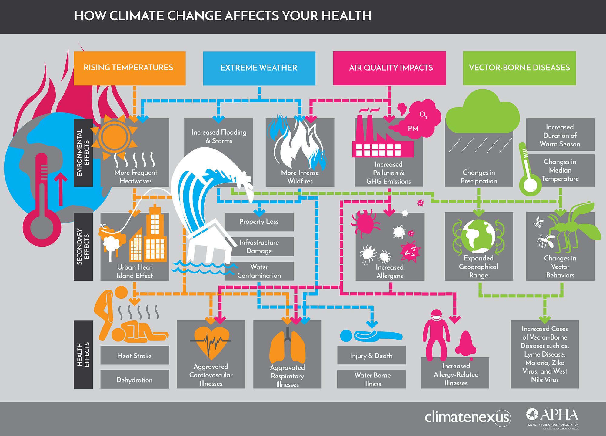
More people than ever before live in cities. In places likely to experience a natural disaster (think tsunamis, or floods on the coast or earthquakes on tectonic fault lines) are especially vulnerable to catastrophe. It's easy to forget the threat when years, or even centuries(!), go by without a disaster, but it's important to remember that in the end, we're not the ones in charge. We rounded up 10 destinations that are in potential danger of being damaged, or even utterly destroyed, by natural disasters:

1. LOS ANGELES


Photo: Greater Los Angeles by: Neil Kremer flickr - Courtesy: Gogobot


Greatest threat: Earthquakes, followed by river flooding Residents of Los Angeles (and all of SoCal) half-jokingly wonder when "The Big One" is going to hit - and by "big one," they mean a catastrophic earthquake along the San Andreas Fault (which runs right beneath Los Angeles) that could topple buildings and essentially flatten downtown. The rumors that California is going to break off the continent and float out to sea are highly exaggerated, but we still don't like to tempt Mother Nature.

2. SAN FRANCISCO


Photo: San Francisco by: Rodrigo - Courtesy: Gogobot


Greatest threat: Earthquakes If Los Angeles is in danger, San Francisco is right in the line of fire. If "The Big One" hits, much of the older city infrastructure will likely be flattened - but don't worry, a giant chasm in the road (like in the film San Andreas) won't open up. Nor will a tsunami topple the Golden Gate Bridge. But plenty of chaos will definitely ensue, like it did after the notorious 1906 earthquake that decimated the city.

3. NAGOYA, JAPAN


Photo: Nagoya by: isado flickr - Courtesy: Gogobot


Greatest threat: Earthquakes, and thus tsunamis With over 23 million people living in this city alone, the threat of tsunamis (the biggest natural disaster threat to Japan as a whole) is a worrisome one. Poor Nagoya is not only right in the direct path of a northern Pacific tsunami, it also faces the threat of the other four main perilous natural disasters: river floods, earthquakes, storm surges, and wind storms.

4. TOKYO, JAPAN


Photo: Tokyo by: James Nash (aka Cirrus) flickr - Courtesy: Gogobot


Greatest threat: Earthquakes, and thus tsunamis It's no secret that Tokyo, with its incredible population density and location right on the Pacific Rim (or 'Ring of Fire' in the geological world) is a sitting duck for earthquakes - and their byproducts, tsunamis. When the catastrophic Tōhoku earthquake struck northern Japan in March 2011? That was several hundred miles from Tokyo, and it shook the city enough to alarm normally earthquake-desensitized residents.

5. CINQUE TERRE, ITALY


Photo: Cinque Terre by: Becky Mahan - Courtesy: Gogobot


Greatest threat: Flooding and landslides (caused by storms) The beautiful string of five colorful villages on the coast was hit by a devastating storm of Biblical proportions in 2011, and rebuilding efforts are still going on. With half the famous hiking trail that connects the five villages still unstable and unsafe for public access, the effects of natural disasters on this region are serious. Of all the destinations on the list, we'd qualify that as the most important to truly "see while you have the chance." (The Cinque Terre is also under threat by a non-natural disaster: too many tourists.)

6. HILO, HAWAII


Photo: Hilo by: Ken Lund flickr - Courtesy: Gogobot


Greatest threat: Volcanic eruption Hilo is very aware of its precarious placement near Mauna Loa - which just so happens to be the largest volcano on earth. It produces more lava than any other Hawaiian volcano, but there's one lucky catch: the lava flows are notoriously slow, which means residents would have plenty of time to evacuate if Moana Loa ever totally blows her top. (Though raining ash and embers render the situation not entirely danger-free, and the city itself would be powerless to escape the damage.)

7. MANAGUA, NICARAGUA


Photo: Masaya Volcano National Park by: GOC53 flickr - Courtesy: Gogobot


Greatest threat: Volcanic eruption Settled just outside the Masaya Volcano National Park, Nicaragua's capital is probably not located in the best place. The national park is a desolate, almost creepy caldera littered with lava rock and wildflowers - oh, and a giant crater that consistently eeks out clouds of sulfur dioxide. The volcano erupted in 2001, 2003, and 2008, and scientists expect it to erupt again any time.

8. NEW ORLEANS, LOUISIANA


Photo: New Orleans by: Celeny Da Silva - Courtesy: Gogobot


Greatest threat: Hurricanes, and thus flooding Americans vividly remember Hurricane Katrina, which decimated the Big Easy when it hit the Louisiana coast in 2005 and caused 1,577 deaths. The levees had to be rebuilt and the infrastructure underwent serious upgrading, but the threat still remains: a significant part of metro New Orleans is not directly protected by the new levees. Plus, the land in the region continues to sink (and sea levels rise), which not a good combination maketh.

9. AMSTERDAM, NETHERLANDS


Photo: Amsterdam by: Claudio.Ar flickr - Courtesy: Gogobot


Greatest threat: Totally disappearing into the sea With Amsterdam, it's basically Humans: 1, Mother Nature: 0. The Dutch are outrageously skilled water masters, with their elaborate system of canals and dikes that keep the North Sea from swallowing up the entire city. The problem is, they suck at keeping it maintained. There was a major flood defense failure in 2010, and experts have said that some of the dams are so fragile they couldn't even sustain hairline cracks. So...give the sea just one good blow to deal, and Amsterdam could potentially become the new Atlantis.

10. WELLINGTON, NEW ZEALAND


Photo: Wellington by: Terry Gardner - Courtesy: Gogobot


Greatest threat: Earthquakes Poor Wellington. The city has managed to develop in a place where everything - like, EVERYTHING - is against it. First off, it's located at the tip of an island...with the water literally lapping at its feet. Though the last major tsunami roared over the place in 1946, the next one is overdue (geologically-wise), thanks to the ginormous active fault line right beneath the city. Oh, and there are a bunch of volcanoes just north of the city (there's a reason Peter Jackson used this region as the landscape for Mordor.)

Wednesday, September 21, 2016

What makes your city walkable?


Published on 6 Jul 2016

American (and Canadian) cities are pretty much made for cars, which means they're not very easy for humans to navigate. And when you consider that cities are supposed to be made for humans to live in -- and that by 2050, two-thirds of the global population will live in cities, which already account for 70 percent of the planet's carbon emissions -- that's a bit of a problem.

In this video they talked to Dan Burden, walkability expert, on what factors are most important to transform cities into places that are easier and more fun to live in, and less impactful on the climate at the same time.

Tuesday, September 20, 2016

World’s oldest rock unit at 4.02 billion years old


September 19, 2016


Samples of the world’s oldest precisely dated rock.
Credit: Image courtesy of University of Alberta

Addressing fundamental unknowns about the earliest history of Earth’s crust, scientists have precisely dated the world’s oldest rock unit at 4.02 billion years old. Driven by the University of Alberta, the findings suggest that early Earth was largely covered with an oceanic crust-like surface.

“It gives us important information about how the early continents formed,” says lead author Jesse Reimink. “Because it’s so far back in time, we have to grasp at every piece of evidence we can. We have very few data points with which to evaluate what was happening on Earth at this time.” In fact, only three locations worldwide exist with rocks or minerals older than 4 billion years old: one from Northern Quebec, mineral grains from Western Australia, and the rock formation from Canada’s Northwest Territories examined in this new study.


While it is well known that the oldest rocks formed prior to 4 billion years ago, the unique twist on Reimink’s rock is the presence of well-preserved grains of the mineral zircon, leaving no doubt about the date it formed. The sample in question was found during fieldwork by Reimink’s PhD supervisor, Tom Chacko, in an area roughly 300 kilometres north of Yellowknife. Reimink recently completed his PhD at the University of Alberta before starting a post-doctoral fellowship at the Carnegie Institute for Science in Washington, D.C.

“Zircons lock in not only the age but also other geochemical information that we’ve exploited in this paper,” Reimink continues. “Rocks and zircon together give us much more information than either on their own. Zircon retains its chemical signature and records age information that doesn’t get reset by later geological events, while the rock itself records chemical information that the zircon grains don’t.”

He explains that the chemistry of the rock itself looks like rocks that are forming today in modern Iceland, which is transitional between oceanic and continental crust. In fact, Iceland has been hypothesized as an analog for how continental crusts started to form.

“We examined the rock itself to analyze those chemical signatures to explore the way that the magma intrudes into the surrounding rock.” One signature in particular recorded the assimilation step of magma from Earth’s crust. “While the magma cooled, it simultaneously heated up and melted the rock around it, and we have evidence for that.”

Reimink says that the lack of signatures of continental crust in this rock, different from what the early continents were expected to look like, leads to more questions than answers. Reimink says one of the biggest challenges as a geologist is that as we travel back in time on Earth, the quantity and quality of available evidence decreases. “Earth is constantly recycling itself, the crust is being deformed or melted, and pre-history is being erased,” remarks Reimink.

“The presence of continents above water and exposed to the atmosphere has huge implications in atmospheric chemistry and the presence or absence of life. The amount of continents on Earth has a large chemical influence both on processes in the deep Earth (mantle and core) and at the Earth’s surface (atmosphere and biosphere). There are constant feedback loops between chemistry and geology. Though there are still a lot of unknowns, this is just one example that everything on Earth is intertwined.” “No evidence for Hadean continental crust within Earth’s oldest evolved rock unit” appears in the October issue of Nature Geoscience.

Story Source:

The above post is reprinted from materials provided by University of Alberta.

Journal Reference:

J. R. Reimink, J. H. F. L. Davies, T. Chacko, R. A. Stern, L. M. Heaman, C. Sarkar, U. Schaltegger, R. A. Creaser, D. G. Pearson. No evidence for Hadean continental crust within Earth’s oldest evolved rock unit. Nature Geoscience, 2016; DOI: 10.1038/ngeo2786

Monday, September 19, 2016

Scientists find 3.7 billion-year-old fossils, oldest known


Fossil bacterial communities uncovered in Greenland by melting ice and snow

CBC Posted: Aug 31, 2016

sm-220-fossils-david_wacey_uwa

The fossils were grouped in clusters and chains similar to those formed by bacteria today. (David Wacey/University of Western Australia)

The earliest fossil evidence of life on Earth has been found in rocks 3.7 billion years old in Greenland, raising chances of life on Mars aeons ago when both planets were similarly desolate, scientists said on Wednesday.

The experts found tiny humps, between one and four centimetres (0.4 and 1.6 inches) tall, in rocks at Isua in south-west Greenland that they said were fossilized groups of microbes similar to ones now found in seas from Bermuda to Australia.

If confirmed as fossilized communities of bacteria known as stromatolites — rather than a freak natural formation — the lumps would pre-date fossils found in Australia as the earliest evidence of life on Earth by 220 million years.

"This indicates the Earth was no longer some sort of hell 3.7 billion years ago," lead author Allen Nutman, of the University of Wollongong, told Reuters of the findings that were published in the journal Nature.

"It was a place where life could flourish."

Earth formed about 4.6 billion years ago and the relative sophistication of stromatolites indicated that life had evolved quickly after a bombardment by asteroids ended about 4 billion years ago.

"Stromatolites contain billions of bacteria ... they're making the equivalent of apartment complexes," said Martin Van Kranendonk, a co-author at the University of New South Wales who identified the previously oldest fossils, dating from 3.48 billion years ago.

At the time stromatolites started growing in gooey masses on a forgotten seabed, the Earth was probably similar to Mars with liquid water at the surface, orbiting a sun that was 30 per cent dimmer than today, the scientists said.

Those parallels could be a new spur to study whether Mars once had life, the authors said.
Mars looks more promising for life

"Suddenly, Mars may look even more promising than before as a potential abode for past life," Abigail Allwood, of the California Institute of Technology, wrote in a commentary in Nature.

The Greenland find was made after a retreat of snow and ice exposed long-hidden rocks. Greenland's government hopes that a thaw linked to global warming will have positive spin-offs, such as exposing more minerals.

Nutman said the main controversy was likely to be that the fossils were in metamorphic rocks, reckoned to have formed under huge stress with temperatures up to 550 C (1,022 F) — usually too high to preserve any trace of life.

Still, Van Kranendonk told Reuters that dried-out biological material could sometimes survive such a baking, adding he was "absolutely convinced" by the Greenland fossils.

Thursday, September 15, 2016

Four Infographics That Show How Climate Change Is Affecting Your Health

Source: Nexus Media
Jeremy Deaton and Mina Lee
August 26, 2016


Source: Mina Lee


The dog days of summer were particularly dogged this year. July clocked in as the hottest month on record, marking the midpoint of what is likely to be thehottest year on record. With sweltering temperatures came a litany of crummy climate news — floods in Louisiana, Zika in Miami, searing heat waves across the Northeast — with dire implications for human health.

Source: NASA

Last year’s Lancet Commission on Health and Climate Change warned that the carbon crisis could undo the last half-century of progress in public health. And yet, for many, it remains unclear how climate change could land them in the hospital. Just one in four Americans can identify the ways that rising temperatures threaten their health.

To clarify that link, Climate Nexus and the American Public Health Association developed a series of infographics that illustrate the connection between climate change and all manner of life-threatening illness. [Disclosure: Climate Nexus and Nexus Media are both sponsored projects ofRockefeller Philanthropy Advisors.]

Let’s begin with air quality. Climate change is producing shorter winters and longer summers, extending allergy season. Warmer weather is also worsening pollution by fueling the formation of ozone. Heat and drought are setting the stage for wildfires, like the blaze recently seen in California, which produce smoke, threatening respiratory health.

Source: Mina Lee

Rising temperatures are also producing longer and more severe heat waves, like the scorcher that just descended on the East Coast. Extreme heat can lead to dehydration and stroke. Children and the elderly are most vulnerable.

Source: Mina Lee

With extreme heat, expect to see more mosquitos. According to an analysisfrom Climate Central, climate change is extending mosquito season across the United States, expanding the range of vector-borne diseases, like Zika, which just made landfall in Florida.

Source: Mina Lee

Finally, severe storms, like the torrent that just hit Louisiana, are damaging infrastructure, leaving those many of those affected without food, shelter or access to clean water.

Source: Mina Lee

The good news is that slashing planet-warming carbon pollution would be a boon for public health. The Lancet Commission said that tackling climate change “could be the greatest global health opportunity of the 21st century.” Drastically reducing emissions from cars, planes, and power plants wouldn’t just curb the rise in temperatures. It would also prevent millions of deaths from air pollution.

As the country shifts to clean energy, we can expect big measurable gains in public health. For Americans currently sweating it out in the summer heat, that might offer a little consolation.


Jeremy Deaton and Mina Lee write and produce original artwork for Nexus Media, a syndicated newswire covering climate, energy, politics, art and culture. You can follow them at @deaton_jeremy and @minalee89.

Wednesday, September 14, 2016

The Blasphemous Geologist Who Rocked Our Understanding of Earth's Age


James Hutton was a leading light of his time, but is rarely talked about today


Hutton, as painted by Sir Henry Raeburn in 1776. (National Galleries of Scotland)

By Jim Morrison
SMITHSONIAN.COM AUGUST 29, 2016

On a June afternoon in 1788, James Hutton stood before a rock outcropping on Scotland’s western coast named Siccar Point. There, before a couple of other members of the Scottish Enlightenment, he staked his claim as the father of modern geology.

As Hutton told the skeptics who accompanied him there by boat, Siccar Point illustrated a blasphemous truth: the Earth was old, almost beyond comprehension.

Three years earlier, he’d unveiled two papers, together called "Theory of the Earth," at a pair of meetings of the Royal Society of Edinburgh. Hutton proposed that the Earth constantly cycled through disrepair and renewal. Exposed rocks and soil were eroded, and formed new sediments that were buried and turned into rock by heat and pressure. That rock eventually uplifted and eroded again, a cycle that continued uninterrupted.

“The result, therefore, of this physical enquiry,” Hutton concluded, “is that we find no vestige of a beginning, no prospect of an end.”

His ideas were startling at a time when most natural philosophers—the term scientist had not yet been coined—believed that the Earth had been created by God roughly 6,000 years earlier. The popular notion was that the world had been in a continual decline ever since the perfection of Eden. Therefore, it had to be young. The King James Bible even set a date: October 23, 4004 BC.

At Siccar Point, Hutton pointed to proof of his theory: the junction of two types of rock created at different times and by different forces. Gray layers of metamorphic rock rose vertically, like weathered boards stuck in the ground. They stabbed into horizontal layers of red, layered sandstone, rock only beginning to be deposited. The gray rock, Hutton explained, had originally been laid down in horizontal layers of perhaps an inch a year of sediment long ago. Over time, subterranean heat and pressure transformed the sediment into rock and then a force caused the strata to buckle, fold and become vertical.

Here, he added, was irrefutable proof the Earth was far older than the prevailing belief of the time.

John Playfair, a mathematician who would go on to become Hutton's biographer with his 1805 book, Life of Dr. Hutton, accompanied him that day. “The mind seemed to grow giddy by looking so far back into the abyss of time; and whilst we listened with earnestness and admiration to the philosopher who was now unfolding to us the order and series of these wonderful events, we became sensible how much further reason may sometimes go than imagination may venture to follow,” he late wrote.

Hutton, born in 1726, never became famous for his theories during his life. It would take a generation before the geologist Charles Lyell and the biologist Charles Darwin would grasp the importance of his work. But his influence endures today.


An illustration of Hutton doing fieldwork, by artist John Kay. (Library of Congress)

"A lot of what is still in practice today in terms of how we think about geology came from Hutton," says Stephen Marshak, a geology professor at the University of Illinois who has made the pilgrimage to Siccar Point twice. To Marshak, Hutton is the father of geology.

Authors like Stephen Jay Gould and Jack Repcheck—who wrote a biography of Hutton titled The Man Who Found Time—credit him with freeing science from religious orthodoxy and laying the foundation for Charles Darwin’s theory of evolution.

"He burst the boundaries of time, thereby establishing geology's most distinctive and transforming contribution to human thought—Deep Time," Gould wrote in 1977.

Hutton developed his theory over 25 years, first while running a farm in eastern Scotland near the border with England and later in an Edinburgh house he built in 1770. There, one visitor wrote that "his study is so full of fossils and chemical apparatus of various kinds that there is barely room to sit down."

He was spared financial worries thanks to income from the farm and other ventures, and had no dependent family members, because he never married. Thus freed of most earthly burdens, he spent his days working in the study and reading. He traveled through Scotland, Wales and England, collecting rocks and surveying the geology. Through chemistry, he determined that rocks could not have precipitated from a catastrophe like Noah’s Flood, the prevailing view of previous centuries, otherwise they would be dissolved by water. Heat and pressure, he realized, formed rocks.

That discovery came with help from Joseph Black, a physician, chemist and the discoverer of carbon dioxide. When Hutton moved to Edinburgh, Black shared his love of chemistry, a key tool to understanding the effect of heat on rock. He deduced the existence of latent heat and the importance of pressure on heated substances. Water, for instance, stays liquid under pressure even when heated to a temperature that normally would transform it to steam. Those ideas about heat and pressure would become key to Hutton’s theory about how buried sediments became rock.

Black and Hutton were among the leading lights of the Royal Society of Edinburgh, along with Adam Smith, the economist and author of The Wealth of Nations, David Hume, the philosopher, Robert Burns, the poet, and James Watt, the inventor of the two-cylinder steam engine that paved the way for the Industrial Revolution.

Hutton's principle of uniformitarianism—that the present is the key to the past—has been a guiding principle in geology and all sciences since. Marshak notes that despite his insight, Hutton didn’t grasp all the foundations of geology. He thought, for example, that everything happened at a similar rate, something that does not account for catastrophic actions like mountain building or volcanic eruptions, which have shaped the Earth.

Unlike many of his contemporaries, Hutton never found fame during his life. But his portrait of an ever-changing planet had a profound effect. Playfair's book fell into favor with Charles Lyell, who was born in 1797, the year that Hutton died. Lyell's first volume of "Principles of Geology" was published in 1830, using Hutton and Playfair as starting points.

Charles Darwin brought a copy aboard the Beagle in 1832 and later became a close friend of Lyell after completing his voyages in 1836. Darwin’s On the Origins of Species owes a debt to Hutton’s concept of deep time and rejection of religious orthodoxy.

"The concept of Deep Time is essential. Now, we take for granted the Earth is 4.5 billion years old. Hutton had no way of knowing it was that kind of age. But he did speculate that the Earth must be very, very old," Marshak says. "That idea ultimately led Darwin to come up with his phrasing of the theory of evolution. Because only by realizing there could be an immense amount of time could evolution produce the diversity of species and also the record of species found in fossils."

"The genealogy of these ideas," he adds, "goes from Hutton to Playfair to Lyell to Darwin."

Tuesday, September 13, 2016

NASA Map Shows Large Portions of Greenland are Melting from Below


robertscribbler
August 9, 2016

During recent years, as human fossil-fuel emissions have forced the Earth to warm,observations of Greenland’s surface has indicated a rising rate of melt. What has been less well-observed is melt rates beneath the ice and near the ice base. This is important because the pooling of water beneath the great ice sheet can help speed its movement toward ocean outlets, along with accumulating heat at the base of the ice — which can also quicken the pace of overall melt.


A new scientific study headed by NASA researchers has developed one of the first comprehensive maps of melt along Greenland’s basal zone, where the ice contacts the ground surface. What they have found is that large portions of Greenland are melting from below:


(New, first-of-its-kind map shows extensive melt along the Greenland ice sheet base. Melt in this region is a sign that heat is building up beneath the ice as well as on top. Image source:NASA.)

This mapping study found that wide expanses of northern Greenland and pretty much all of southern Greenland are now experiencing melt at the ice sheet base. As the interior of Greenland has a cracked-bowl topography — with land bowing down into a central trough and numerous furrows connecting the ice sheet with the ocean — understanding where liquid water and heat are pooling at the bottom of the ice sheet will help scientists to get a better idea of how Greenland’s glaciers will respond to human-forced warming.

Joe MacGregor, lead study author and glaciologist at NASA’s Goddard Space Flight Center in Greenbelt, Maryland recently noted:

“We’re ultimately interested in understanding how the ice sheet flows and how it will behave in the future. If the ice at its bottom is at the melting-point temperature, or thawed, then there could be enough liquid water there for the ice to flow faster and affect how quickly it responds to climate change.”

Geothermal Melt, Ice Sheet Heat Accumulation, and Climate Change

Melt along the base of the Greenland ice sheet has long been influenced by heat welling up from or trapped near the Earth’s surface. The heavy, thick ice sheet densely packs the ground and rocks under it, which generates and amplifies geothermal hot-spots beneath Greenland. In addition, the ice creates a kind of insulating layer which locks that ground heat in. As a result, the bottom of the ice sheet is often tens of degrees warmer than its top.

Alone, this blanketing effect is enough to generate some melt along the bottom of Greenland. But now that the surface is melting more and more, heat transport from the ice surface to the bottom via liquid water funneling down to pool below is a more common occurrence.


(Recharge of subglacial lake by surface melt near the Flade Isblink ice cap is an example of how surface melt can interact with basal melt, driving the formation of water at the ice sheet base. Image source: Nature.)

The way this heat transfer works is that rising temperatures over Greenland form more extensive surface lakes and melt ponds during the increasingly warm summers (and sometimes briefly during other periods). Often, the meltwater will find a crack in the ice and flow down to the ice interior. Sometimes the water remains suspended in the middle layers between the surface and the ice sheet base as a kind of heat bubble. At other times, the water will bore all the way down to the ground where it can form into pools or subglacial lakes.

At Flade Isblink in northeastern Greenland, such a filling of a subglacial lake was observed during the 2011 and 2012 melt years. As Greenland warms, such instances are likely to become more common. In this way, melt at the surface can add to the amount of heat trapped below the ice sheet — forming a kind of synergistic melt process.

The new NASA study helps our understanding of how such a process might unfold by showing the current extent of subsurface melt. The study combined physical models with observations to create this larger picture of bottom melt, telling a dramatic story of the opening period of human-forced Greenland melt, in which sub-surface melt is already very extensive.

Conditions in Context — The Level of Atmospheric Greenhouse Gasses is Now About Equal to Where They Were When the Greenland Ice Sheet First Formed

In context, the Greenland ice sheet is the largest repository of land ice remaining in the Northern Hemisphere. Covering a vast region of 1,710,000 square kilometers and rising up to 3 kilometers high at its tallest point, this ice sheet contains fully 2,850,000 cubic kilometers of ice. If all this ice melted, it would raise the world’s sea levels by around 7.2 meters (nearly 24 feet).

This enormous mountain of ice astride Greenland began to form about 11 to 18 million years ago during the Middle Miocene climate epoch. Back then, atmospheric carbon dioxide ranged from 405 to 500 parts per million. This decline from earlier, higher CO2 concentrations was allowing the world to cool enough to begin to support glacial ice in this region (around 4 C warmer than 1880s values).


(Losses of Greenland mass from the surface zone have been accelerating during recent years. This loss has primarily been driven by human-forced warming of the Arctic. Though the North Atlantic Oscillation can generate melt variability by driving warm air flows toward or away from Greenland, the overall long-term driver has been a rapid warming of the Arctic region due to fossil-fuel emissions. Though we have a pretty good understanding of surface melt, our understanding of melt at the base of the ice sheet and heat accumulation there is less complete. Such an understanding may help us to predict future ice sheet behavior. Image source: Skeptical Science.)

Back then, Greenland’s ice was far smaller, far less extensive. It was a baby ice sheet that would grow into a behemoth as the Miocene cooled into the Pliocene — when CO2 levels fell to around 390 to 405 ppm — and then into the various ice ages and interglacials that followed (featuring atmospheric CO2 in the range of around 180 ppm during ice ages and around 275 ppm during interglacials).

Now, human fossil-fuel burning has put the ice sheet in a great global-warming time machine. With atmospheric CO2 levels hitting Middle Miocene ranges of 407.5 ppm at Mauna Loa this year, an accumulation of enough heat to significantly melt large portions of Greenland’s ice is a very real and growing concern. Exactly how that melt may unfold is still a big scientific mystery, but the risks are growing along with the heat and the new NASA basal melt study helps to shed a little light.

Links:

First Map of Thawed Areas Under Greenland Ice Sheet

NASA Maps Thawed Areas Under the Greenland Ice Sheet

Recharge of Subglacial Lake by Surface Melt Water in Northeast Greenland

Pliocene

Middle Miocene

Greenland Ice Sheet

Monday, September 12, 2016

Map & Compass: How To Navigate And Orienteer

July 5, 2016
Stephen Regenold


You’re running through the woods, a map in your hand. A compass points direction as you race the clock, looking for hidden flags.


This is orienteering, a sport of quick thinking and backwoods navigation where a wrong move will get you seriously lost.

The skills used by orienteers are fundamental to off-trail navigation.

Forget GPS devices. A good orienteer is faster. A compass is more reliable. A good map is more accurate. Expert orienteers can be dropped any place on the planet, handed a map and a compass, and find their way out. Learn these skills and become a master of backwoods travel.
Primer: How To Orienteer

This quick guide to orienteering basics is a primer for experienced backwoods wanderers and the directionally challenged alike. Apply these tricks next time you’re in the woods with a map on an adventure of your own.


Topo lines and control points (red circles) are part of the visual language of orienteering

Orienting A Map

The sport’s name comes from a basic map maneuver: Orienting the map to mimic your environment. Essentially, the top of an orienteering map — which always represents north — needs to always be facing to the north no matter which direction you’re facing.

For example, if you’re standing on a trail looking north, holding a map horizontally in your hands, the map can be held normally (all text and characters right side up). But flip around so you’re looking south, and the map needs to be read upside-down to mimic reality. The top of the page will still be facing north.

Same thing if you turn to face east or west; keep the top of the map always to the north. The technique keeps features mirrored to their representation on the printed page.
Using A Compass

One simple rule: All you need to know is north. Modern compasses can come with mirrors, degree markings, spinning dials, and sights. For most basic navigation, all these accouterments are not needed.


An orienteering thumb compass

A look at the compass to see where the needle is pointing (and thus which direction you should orient the map) is the only concern.

Attack Points: Navigate From World Features

A technique for finding an orienteering flag — or any precise point on a map — is an attack point. These physical features or landforms can be used as a directional. Say a destination is deep in a thick section of forest. Instead of wandering in to search, identify a nearby trail intersection, bend in a creek, or other standout land feature.

At the prominent feature — the attack point — line up a route to your ultimate destination, estimating direction and distance from the map. It might be 300 meters southeast, for example. Take that knowledge, get a compass bearing, and go.
Map Skills

A common orienteering map reveals a tangle of topographical lines and esoteric iconography representing everything from boulders and bogs to power lines, fences, hills, ravines, and depressions in the land. Blotchy yellows and greens portray vegetation boundaries. Lake and rivers are blue. Buildings look like blocks. Roads and trails are represented by lines, dotted and solid.


Close up: Typical orienteering map

The graphical overload can be confusing at first. But the system of shapes and lines — developed in Scandinavia and honed over decades — becomes a streamlined system of information for experienced orienteers.

These maps are similar to simple topographical maps used to the navigate backcountry. If unfamiliar, spend some time studying your maps and seeing how features relate from the map to the real world.
Map Scale

Typical wilderness maps from the United States Geological Survey are of the 1:24,000 scale variety or greater. In orienteering, the most common scale is 1:10,000, which hugely increases the amount of detail. An inch on a 1:24,000 scale map, for example, represents about 2,000 feet in the real world; in the 1:10,000 scale an inch equals about 800 feet. This greater detail allows for extremely precise navigation. In orienteering, objects such as boulders, park benches, picnic tables, fences, and the subtle crooks of a ravine are obvious on maps of 1:10,000 scale.


‘Thumb’ The Map For Position

Orienteers often run with a map in hand, keeping a thumb planted on the map near their current location.

The technique is simple: As you hike or run through the landscape, move your thumb to the new place on the page to represent your current position.

Reposition your thumb at stops, at major land features, or before heading into a tricky section of the course. The technique keeps you more focused on the navigation at hand and lets you see, at a fast glance while moving, your approximate location among the tangle of mapped detail at any time.

–Learn more and find local orienteering meets and clubs at the United States Orienteering Federation.

Friday, September 9, 2016

Plate tectonics: new findings fill out the 50-year-old theory that explains Earth’s landmasses

Philip Heron


Plate tectonics: new findings fill out the 50-year-old theory that explains Earth’s landmasses


Fifty years ago, there was a seismic shift away from the longstanding belief that Earth’s continents were permanently stationary.

In 1966, J. Tuzo Wilson published Did the Atlantic Close and then Re-Open? in the journal Nature. The Canadian author introduced to the mainstream the idea that continents and oceans are in continuous motion over our planet’s surface. Known as plate tectonics, the theory describes the large-scale motion of the outer layer of the Earth.

It explains tectonic activity (things like earthquakes and the building of mountain ranges) at the edges of continental landmasses (for instance, the San Andreas Fault in California and the Andes in South America).

At 50 years old, with a surge of interest in where the surface of our planet has been and where it’s going, scientists are reassessing what plate tectonics does a good job of explaining – and puzzling over where new findings might fit in.

Evidence for the theory

Although the widespread acceptance of the theory of plate tectonics is younger than Barack Obama, German scientist Alfred Wegener first advanced the hypothesis back in 1912.

He noted that the Earth’s current landmasses could fit together like a jigsaw puzzle. After analyzing fossil records that showed similar species once lived in now geographically remote locations, meteorologist Wegener proposed that the continents had once been fused. But without a mechanism to explain how the continents could actually “drift,” most geologists dismissed his ideas. His “amateur” status, combined with anti-German sentiment in the period after World War I, meant his hypothesis was deemed speculative at best.


A map of the original supercontinent, Pangaea, with modern continent outlines. Kieff, CC BY-SA

In 1966, Tuzo Wilson built on earlier ideas to provide a missing link: the Atlantic ocean had opened and closed at least once before. By studying rock types, he found that parts of New England and Canada were of European origin, and that parts of Norway and Scotland were American. From this evidence, Wilson showed that the Atlantic Ocean had opened, closed and re-opened again, taking parts of its neighboring landmasses with it.

And there it was: proof our planet’s continents were not stationary.


The 15 major plates on our planet’s surface. USGS


How plate tectonics works

Earth’s crust and top part of the mantle (the next layer in toward the core of our planet) run about 150 km deep. Together, they’re called the lithosphere and make up the “plates” in plate tectonics. We now know there are 15 major plates that cover the planet’s surface, moving at around the speed at which our fingernails grow.

Based on radiometric dating of rocks, we know that no ocean is more than 200 million years old, though our continents are much older. The oceans’ opening and closing process – called the Wilson cycle – explains how the Earth’s surface evolves.

A continent breaks up due changes in the way molten rock in the Earth’s interior is flowing. That in turn acts on the lithosphere, changing the direction plates move. This is how, for instance, South America broke away from Africa. The next step is continental drift, sea-floor spreading, ocean formation – and hello, Atlantic Ocean. In fact, the Atlantic is still opening, generating new plate material in the middle of the ocean and making the flight from New York to London a few inches longer each year.


A simplified ‘Wilson Cycle’. Philip Heron, CC BY

Oceans close when their?? tectonic plate sinks beneath another, a process geologists call subduction. Off the Pacific Northwest coast of the United States, the ocean is slipping under the continent and into the mantle below the lithosphere, creating in slow motion Mount St Helens and the Cascade mountain range.

In addition to undergoing spreading (construction) and subduction (destruction), plates can simply rub up against each other - usually generating large earthquakes. These interactions, also discovered by Tuzo Wilson back in the 1960s, are termed “conservative.” All three processes occur at the edges of plate boundaries.

But the conventional theory of plate tectonics stumbles when it tries to explain some things. For example, what produces mountain ranges and earthquakes that occur within continental interiors, far from plate boundaries?


Gone but not forgotten

The answer may lie in a map of ancient continental collisions my colleagues and I assembled.

Over the past 20 years, improved computer power and mathematical techniques have allowed researchers to more clearly look below the Earth’s crust and explore the deeper parts of our plates. Globally, we find many instances of scarring left over from the ancient collisions of continents that formed our present-day continental interiors.


Present day plate boundaries (white) with hidden ancient plate boundaries that may reactivate to control plate tectonics (yellow). Regions where anomalous scarring beneath the crust are marked by yellow crosses. Philip Heron, CC BY

A map of ancient continental collisions may represent regions of hidden tectonic activity. These old impressions below the Earth’s crust may still govern surface processes – despite being so far beneath the surface. If these deep scarred structures (more than 30 km down) were reactivated, they would cause devastating new tectonic activity.

It looks like previous plate boundaries (of which there are many) may never really disappear. These inherited structures contribute to geological evolution, and may be why we see geological activity within current continental interiors.

Mysterious blobs 2,900 km down
Modern geophysical imaging also shows two chemical “blobs” at the boundary of Earth’s core and mantle – thought to possibly stem from our planet’s formation.

These hot, dense piles of material lie beneath Africa and the Pacific. Located more than 2,900 km below the Earth’s surface, they’re difficult to study. And nobody knows where they came from or what they do. When these blobs of anomalous substance interact with cold ocean floor that has subducted from the surface down to the deep mantle, they generate hot plumes of mantle and blob material that cause super-volcanoes at the surface.

Does this mean plate tectonic processes control how these piles behave? Or is it that the deep blobs of the unknown are actually controlling what we see at the surface, by releasing hot material to break apart continents?

Answers to these questions have the potential to shake the very foundations of plate tectonics.


Arizona State seismology expert Ed Garnero’s summary of how far we have come in over 100 years of studying the interior of the Earth. Ed Garnero, CC BY


Plate tectonics in other times and places
And the biggest question of all remains unsolved: How did plate tectonics even begin?

The early Earth’s interior had significantly hotter temperatures – and therefore different physical properties – than current conditions. Plate tectonics then may not be the same as what our conventional theory dictates today. What we understand of today’s Earth may have little bearing on its earliest beginnings; we might as well be thinking about an entirely different world.

In the coming years, we may be able to apply what we discover about how plate tectonics got started here to actual other worlds – the billions of exoplanets found in the habitable zone of our universe.

So far, amazingly, Earth is the only planet we know of that has plate tectonics. In our solar system, for example, Venus is often considered Earth’s twin - just with a hellish climate and complete lack of plate tectonics.

Incredibly, the ability of a planet to generate complex life is inextricably linked to plate tectonics. A gridlocked planetary surface has helped produce Venus’ inhabitable toxic atmosphere of 96 percent CO₂. On Earth, subduction helps push carbon down into the planet’s interior and out of the atmosphere.

It’s still difficult to explain how complex life exploded all over our world 500 million years ago, but the processes of removing carbon dioxide from the atmosphere is further helped by continental coverage. An exceptionally slow process starts with carbon dioxide mixing with rain water to wear down continental rocks. This combination can form carbon-rich limestone that subsequently washes away to the ocean floor. The long removal processes (even for geologic time) eventually could create a more breathable atmosphere. It just took 3 billion years of plate tectonic processes to get the right carbon balance for life on Earth.


A theory works now, but what’s in the future?

Fifty years on from Wilson’s 1966 paper, geophysicists have progressed from believing continents never moved to thinking that every movement may leave a lasting memory on our Earth.

Life here would be vastly different if plate tectonics changed its style – as we know it can. A changing mantle temperature may affect the interaction of our lithosphere with the rest of the interior, stopping plate tectonics. Or those continent-sized chemical blobs could move from their relatively stable state, causing super-volcanoes as they release material from their deep reservoirs.

It’s hard to understand what our future holds if we don’t understand our beginning. By discovering the secrets of our past, we may be able to predict the motion of our plate tectonic future.

Thursday, September 8, 2016

To stop Earth's sixth extinction, a biologist says we must give up half the planet

Edward O. Wilson
Jun. 15, 2016, 6:13 AM 
Original post: Tech Insider


Germany's Chancellor Angela Merkel (wearing blue jacket) and delegates look at a computerized model of the earth "Geo-Cosmos" while visiting Miraikan (National Museum of Emerging Science and Innovation) in Tokyo. Reuters/Issei Kato


The following is an excerpt from "Half-Earth: Our Planet's Fight For Life," by Edward O. Wilson.

The global conservation movement has temporarily mitigated but hardly stopped the ongoing extinction of species.

The rate of loss is instead accelerating.

If biodiversity is to be returned to the baseline level of extinction that existed before the spread of humanity, and thus saved for future generations, the conservation effort must be raised to a new level.

The only solution to the “Sixth Extinction” is to increase the area of inviolable natural reserves to half the surface of the Earth or greater.

This expansion is favored by unplanned consequences of ongoing human population growth and movement and evolution of the economy now driven by the digital revolution. But it also requires a fundamental shift in moral reasoning concerning our relation to the living environment.

At the end of the day, the central question of biodiversity conservation is how many of the surviving wildlands and the species within them will be lost before the extinction rate is returned to the prehuman level.

The prehuman rate is now put at one to ten species extinguished per million species each year.

In terms of a human life span that primordial rate is infinitesimal, essentially zero in conservation thinking.

(Keep in mind also that as many as six million contemporary species remain undiscovered by scientists.)

Yet it also means that the current rate of extinction of the well-known species is up by a multiple of close to one thousand and accelerating — despite the heroic best efforts of the global conservation movement.

Unstanched hemorrhaging has only one end in all biological systems: death for an organism, extinction for a species.

Researchers who study the trajectory of biodiversity loss are alarmed that within the century an exponentially rising extinction rate might easily wipe out most of the species still surviving at the present time.


Harvard biology professor Edward O. Wilson.AP/Chitose Suzuki


The crucial factor in the life and death of species is the amount of suitable habitat left to them.

The relation between habitat area and number of species has been calculated and refined many times and cited often in scientific and popular literature.

It is that a change in area of a habitat, up or down, results in a change in the sustainable number of species by the third to fifth root, most commonly close to the fourth root.

In this last case, when, for example, 90 percent of the area is removed, the number that can persist sustainably will descend to about a half. Such is the actual condition of many of the most species-rich localities around the world, including Madagascar, the Mediterranean perimeter, parts of continental southwestern Asia, Polynesia, and many of the islands of the Philippines and the West Indies. If 10 percent of the remaining natural habitat were then also removed—a team of lumbermen might do it in a month—most or all of the surviving resident species would disappear.


A Lemur hangs on a tree in Madagascar's Mantadia National Park. AP/Jerome Delay


If, on the other hand, with the relation of sustainable species to the area of their habitat at the fourth root (the approximate median value), the fraction protected in one-half the global surface is about 85 percent. That fraction can be increased by including within the one-half Earth “hot spots,” where the largest numbers of endangered species exist.

Today every sovereign nation in the world has a protected area system of some kind. All together the reserves number about a hundred sixty-one thousand on land and sixty-five hundred over marine waters. According to the World Database on Protected Areas, a joint project of the United Nations Environmental Program and the International Union for Conservation of Nature, they occupied by 2015 a little less than 15 percent of Earth’s land area and 2.8 percent of Earth’s ocean area. The coverage is increasing gradually. This trend is encouraging. To have reached the existing level is a tribute to those who have led and participated in the global conservation effort. But is the level enough to not just slow but halt the acceleration of species extinction?

Unfortunately, it is in fact nowhere close to enough. Might the upward trend conservation efforts have set be enough during the rest of the century to save most of Earth’s biodiversity? That is problematic, but I doubt that it can be, and even then there will be far less biodiversity to save.


REUTERS/Yannis Behrakis


Even in the best scenarios of conventional conservation practice the losses should be considered unacceptable by civilized peoples. The declining world of biodiversity cannot be saved by the piece meal operations in current use alone. It will certainly be mostly lost if conservation continues to be treated as a luxury item in national budgets. The extinction rate our behavior is now imposing on the rest of life, and seems destined to continue, is more correctly viewed as the equivalent of a Chicxulub-sized asteroid strike played out over several human generations.

The only hope for the species still living is a human effort commensurate with the magnitude of the problem. The ongoing mass extinction of species, and with it the extinction of genes and ecosystems, ranks with pandemics, world war, and climate change as among the deadliest threats that humanity has imposed on itself. To those who feel content to let the Anthropocene evolve toward what ever destiny it mindlessly drifts, I say please take time to reconsider. To those who are steering the growth of reserves worldwide, let me make an earnest request: don’t stop, just aim a lot higher.

Populations of species that were dangerously small will have space to grow. Rare and local species previously doomed by development will escape their fate. The unknown species, apparently at least six million in number, will no longer remain silent and thereby be put at highest risk. People will have closer access to a world that is complex and beautiful beyond our present imagining. We will have more time to put our own house in order for future generations. Living Earth, all of it, can continue to breathe.

Excerpted from "Half-Earth: Our Planet’s Fight for Life," by Edward O. Wilson. Copyright © 2016 by Edward O. Wilson. All rights reserved.